Mittagsspitze (Sarntaler Alpen)
| Mittagsspitze | ||
|---|---|---|
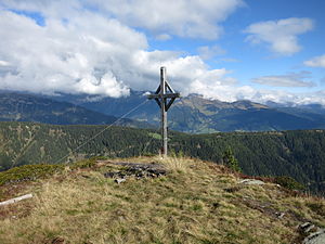
 Gipfelkreuz der Mittagsspitze |
||
| Höhe | 2049 m s.l.m. | |
| Lage | Südtirol, Italien | |
| Gebirge | Sarntaler Alpen | |
| Koordinaten | 46° 50′ 25″ N, 11° 21′ 33″ O | |
|
|
||
Die Mittagsspitze[1] (italienisch Punta del Mezzodì) ist ein 2049 m s.l.m. (nach anderen Angaben 2052 m) hoher Berg in den Sarntaler Alpen in Südtirol. Er befindet sich am Ende des inneren Jaufentals auf dem Gebiet der Gemeinde Ratschings. Im Jahre 2011 wurde dort ein Gipfelkreuz aufgestellt.
Anmerkungen
- ↑ So der Name auf dem Gipfelkreuz, der Name erscheint in diversen Kartenwerken variabel. Die Kompass Karten wählen die Schreibung Mittagspitze, die topographische Karte Tabacco 038 (Sterzing-Stubaier Alpen) 1:25000 schreibt Mittagspitz.
License Information of Images on page#
| Image Description | Credit | Artist | License Name | File |
|---|---|---|---|---|
| a map symbol for a mountain, the center is in the middle of the base line - as opposed to Fire.svg | Eigenes Werk | Herzi Pinki | Datei:BlackMountain.svg | |
| Physische Positionskarte von Südtirol , Italien | own work, using United States National Imagery and Mapping Agency data Generic Mapping Tools | NordNordWest , relief by Lencer | Datei:Italy Bolzano-Bozen relief location map.jpg | |
| Mittagsspitze, mountain above the valley Jaufental, South Tyrol | Eigenes Werk | Ramessos | Datei:MittagsspitzeJaufental01.jpg |


