Zagros Mountains#

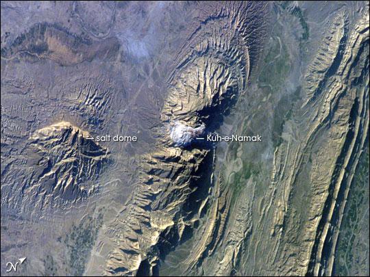
This astronaut photograph of the southwestern edge of the Zagros mountain belt includes another common feature of the region - a salt dome (Kuh-e-Namak or "mountain of salt" in Farsi). Thick layers of minerals such as halite (table salt) typically accumulate in closed basins during alternating wet and dry climatic conditions.
Over geologic time, these layers of salt are buried under younger layers of rock. The pressure from overlying rock layers causes the lower-density salt to flow upwards, bending the overlying rock layers and creating a dome-like structure. Erosion has spectacularly revealed the uplifted tan and brown rock layers surrounding the white Kuh-e-Namak to the northwest and southeast (center of image).
Radial drainage patterns indicate another salt dome is located to the southwest (image left center). If the rising plug of salt (called a salt diapir) breaches the surface, it can become a flowing salt glacier. Salt domes are an important target for oil exploration, as the impermeable salt frequently traps petroleum beneath other rock layers.