Baikal Lake#
Photos by Stanislav Sedov and Sergey Rumyantsev,
members of the AirPano Team that is a member of the global-geography Consortium.
17 February 2014
with kind permission of AirPano
Lake Baikal, Russia
Visiting Lake Baikal was my childhood dream. Finally I had an opportunity to make my dream come true! Stanislav, Sedov, and I were sent to photograph Lake Baikal as a part of the AirPano project.
People from "Baikalika" (a travel company that organized our photo expedition) met us at the Irkutsk airport. Their huge battered Nissan Safari jeep impressed us at first sight. It was a serious car made to concur off-road and ice conditions. I noticed large wooden boards on top of the jeep and said as a joke: "Are we going to build a house?"
"No. We'll need those in case we go under ice," said our driver Alexei.
"Oh, is there a chance that we will?" I asked.
"Well, while I've only had my car fully sink into the water once, there were several times when the water reached the roof of the car." replied Alexei.
His answer made me realize that we were in for a not-so-boring trip.
© AirPano
The drive from Irkutsk, on the deserted ice road, to our final destination, Olkhon Island, took us about 4 hours. We even had time for a quick stop at a roadside Buryati café where they served delicious moderately-priced food. There was a severe snowfall over Baikal a few days before our arrival, so we were not sure if we would see clear ice at all. As you can imagine, we were very anxious. One look down from the mountaintop brought a sigh of disappointment: the Small Sea Strait (a part of Lake Baikal separating Olkhon Island and the western shore of the lake) was white as far as we could see it. The ice road that connected mainland with the island was cleared down to the ice level, but there were one-meter high snowdrifts along each side. However, we were not completely out of luck. A few kilometers down the road it became obvious that snow didn't cover the lake surface completely: we saw ice patches shining between piles of snow; and when we reached the shore and saw meter-long icicles hanging from the rocks, our spirits lifted. Now we knew what we were going to do during following several days -look for clear ice!
We reached the village of Khuzhir, the administrative capital of Olkhon, in the dark; and we had to be at Cape Hoboy, the most-southern point of the island, by sunrise. This is where the Small and the Large Sea Straits of Lake Baikal connect. In the winter, fishermen constantly make new ice routs across the frozen lake to avoid ice cracks, so there are a lot of different roads.

© AirPano
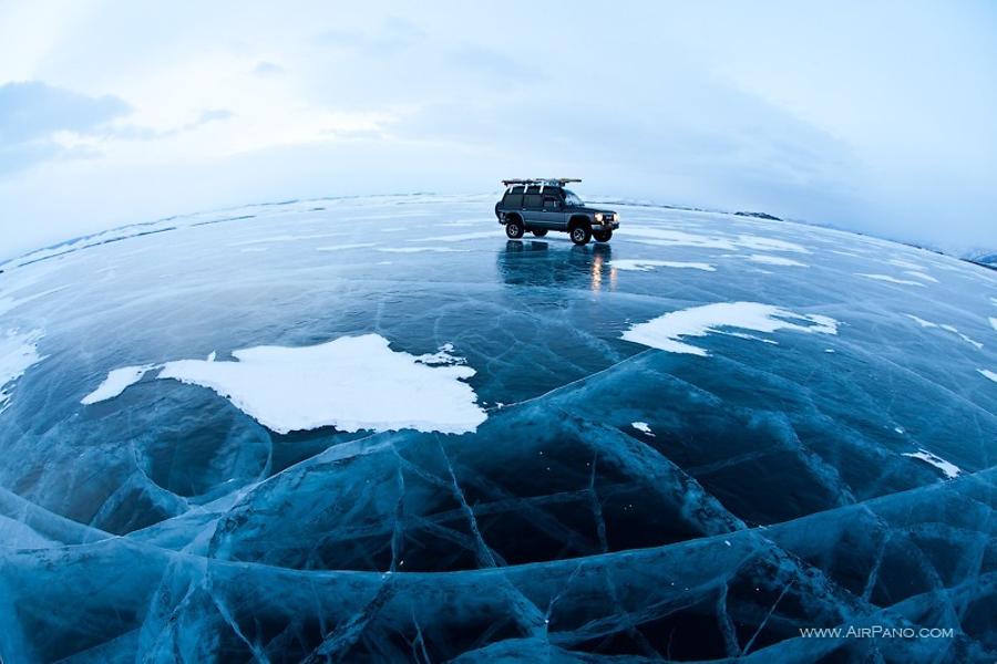
We left our hotel in the dark. The thirty kilometers to Cape Hoboy were covered in snow, so we had to push our way through half-meter snowdrifts. Locals couldn't remember such an unprecedented snowfall over Baikal Lake at all! However, as soon as we passed Cape Hoboy in the morning dusk and reached the Large Sea Strait, the snow stopped as if it was turned off. There were huge snowdrifts on the Olkhon side; and there were only small snow patches that looked like snake scales on the shiny surface of the lake on the other side. The ice was perfect: a clear, smooth surface speckled with white air bubbles and adorned with a whimsical pattern of cracks. There is a local saying, "When you see Baikal ice for the first time, it drives you crazy." It worked for me for sure! Like a child, I jumped, slid, and rolled on ice, staring at ice cracks and colorful ice ridges. However, my euphoria passed quickly as we had to get ready for our first flight.
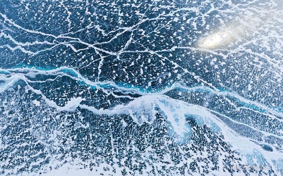
The sun peeked through the clouds and Baikal started to glitter. The flight went well. The view from above turned out to be very unusual. It seemed that the entire lake was covered with a spotty armor: patches of snow formed a chaotic but beautiful giant pattern. This is how Lake Baikal looks only in a very snowy winter.
© AirPano
When the morning gloom cleared, we saw the eastern shore of the lake. It looked so close, that we asked our driver:
"Why do they call Baikal the Big Sea? It's only 10 kilometers wide across this point."
"Ten kilometers?" Alexei was surprised, "No. It's over 70 kilometers wide!"
We were shocked: it was over 70 kilometers to the eastern shore, which we could clearly see; and it was about 30 kilometers to the western shore where every hill was perfectly visible. It looked like one could just walk there effortlessly. According to Alexei, we were not the only people that got caught by the optical illusion: an absolutely clear air and almost-kilometer-high ridges around the lake create an effect of apparent proximity.
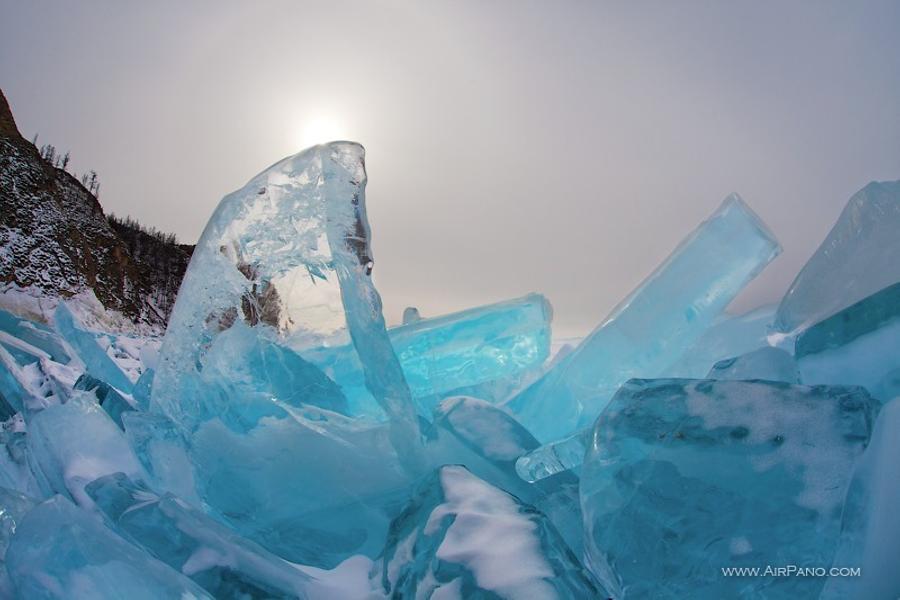
And then we found a cave in a waterfront rock... Walls of the cave were covered with two-meter-thick ice, and hundreds of icicles hanged from the ceiling — an unearthly beauty! Cape Hoboy also greeted us with the largest ice hummocks. It is hard to imagine the way gigantic blocks of turquoise ice got piled one on top of another. We didn't see how Lake Baikal breaks one-meter thick ice, but our driver told us that it was a magnifying, and at the same time, terrifying sight.
© AirPano
The morning frost was so strong that it created additional technical difficulties for our RC helicopter. However, we managed to bring our "bird" up to 250 meters high and took unique pictures of Cape Hoboy. The weather during our first day was in our favor: frost sealed up numerous ice cracks, allowing us to drive on ice to the Uzury village, which was almost unreachable during spring time. In addition, we were awarded for our determination by another miracle of nature — the halo, a circle of rainbow-colored light around the sun.
We spent the following day-and-a-half shooting various sights of Olkhon Island, covering dozens of kilometers on ice. There was only one path through the ice hummocks that was large enough for our car, so every time we had to take the same path crossing one-and-the-same permanent crack in the ice that connected both shores of the Small Sea Strait. Suddenly it got warmer at the lake. One evening on the way back from a photo shoot we saw glistering water instead of ice in the wide open crack! Alexei stepped on the gas, our jeep roared, shook us hard, and sprayed icy water everywhere — we jumped to the other side. To be honest, it took only a couple of seconds. Stas only asked from the back seat, "What happened?" We stopped to have a look: edges around the ice crack were broken, which meant that this path was closed for us for good.
We were supposed to go to Listvyanka village in the morning. They found the clearest ice there. Unfortunately, Cape Olkhon didn't like our early departure — it snowed at night and the entire ice surface turned white. Driving on ice in such conditions would be suicide, so after a short brainstorm we decided to try to outrun the bad weather and drive 500 kilometers to Listvyanka on an asphalt road. We hoped to get there before snow covers the ice.
As we got closer to Irkoutsk, the weather warmed up to +7°C. Ice near Listvyanka was in fact much clearer than at Cape Olkhon, but we still couldn't find an absolutely clear spot. However, due to extreme temperature changes, ice started to crack all over the place. Ice cracks grew like mushrooms after rain. Lake Baikal groaned and cursed as far as we could hear it. With great effort we made it to Bolshie Koty (Big Cats) settlement and — what a miracle! — we found our perfect ice. Unfortunately, very strong wind didn't let us fly, and so we decided to look around. Alas, opened cracks and water stopped us from further driving. Our only option was to stay put at the clear ice spot and wait for the wind to calm down. It took us 4 hours, but now we have a perfect aerial panorama of pure Baikal ice. Yes! The pattern of ice cracks resembles an Arabic calligraphy. Beautiful.
© AirPano
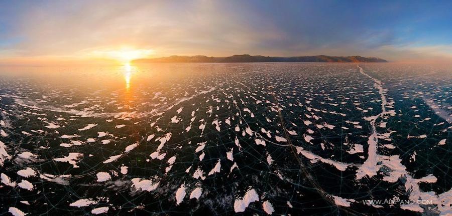
Happy and satisfied, we get back on the ice road and suddenly find a wide path leading to the center of the lake. In 5-7 kilometers we spot little houses on ice: it turned out to be a research camp of the Baikal Research Institute. We get our RC helicopter up in the air near the camp to capture the last rays of the sun. Our 500-kilometer drive was not for nothing! An amazing sunset was our parting gift from Lake Baikal. On the following day the weather suddenly went bad. We couldn't fly over the mouth of Angara River due to the horrible wind.
During our short trip to Lake Baikal we managed to photograph a number of beautiful places, which you can see in our virtual photo tour.
And now allow us to share few interesting facts about Lake Baikal.
Lake Baikal is the deepest lake on the planet, and is one of the most famous landmarks of Russia and the world. In 1996 Lake Baikal was declared a UNESCO World Heritage Site. The surface area of the lake is 31,722 sq. kilometers (12,248 sq. mi), which is comparable to the size of Belgium and Denmark. Its shore length is 2,000 kilometers (1,300 mi), and maximum depth is 1,642 meters. Besides Lake Baikal, there are two more "thousanders" in the world: Lake Tanganyikain in Central Africa (1,470 meters) and the Caspian Sea (1,025 meters). This is not a coincidence: like the enclosed Caspian reservoir, Baikal is also called "a sea" for its size and significance.
Lake Baikal is the largest reservoir of fresh water. It is fed by 336 inflowing rivers and is drained though a single outlet — the Angara River. Scientists believe that if all inflowing rivers suddenly stop, the Angara River would continue its flow for 400 years before draining the lake completely. And if we freeze all Baikal water, cut ice blocks of 1 cubic kilometer size, and line them up, the line would stretch from the North Pole to the South Pole, and 2.5 thousand kilometers further beyond the South Pole mark.
Lake Baikal's age is estimated at 25 — 35 million years, however its origin still raises scientific debates. Average life expectancy of most lakes around the world, especially those that were formed during the Ice Age, is about 10 — 15 thousand years, after which a lake is filled with muddy sediments and gradually becomes a swamp. However Lake Baikal doesn't show any signs of "aging". Its depth doesn't diminish. Moreover, Baikal claims 2 centimeters of land every year. There is a hypothesis that Lake Baikal is in fact an emerging ocean.
Lake Baikal hosts around 2,600 of animal species, most of which are endemic. Besides its unique biodiversity and natural beauty of surrounding landscapes, Lake Baikal is also famous for the clarity of its water. One can see details of an object as deep as 40 meters. Thanks to phytoplankton that lives in Lake Baikal and serves as a biological filter, water in the lake contains the most concentration of oxygen, which makes Baikal water truly alive.
Despite the fact that Baikal is a lake, severe storms occur here just as they do in the ocean; and sometimes Baikal waves reach up to 4-5 meters. No swimmer has been able to cross Lake Baikal yet, mostly due to the average water temperature, which fluctuates around +10°C. However, the number of sunny days in Lake Baikal region is greater than in southern regions of Russia. For example, Olkhon Island (the biggest island on the lake) gets over 300 clear sunny days a year.
All the above-mentioned facts combined with a beautiful picturesque nature put Lake Baikal next to the most outstanding landmarks of the world. And, the winter atmosphere captured on our photographs undoubtedly adds a special charm to the landscape.