Caroline Atoll. Kiribati#
Photos and text by Ádám Plézer,
member of the AirPano Team that is a member of the global-geography Consortium.
2 July 2020
with kind permission of AirPano
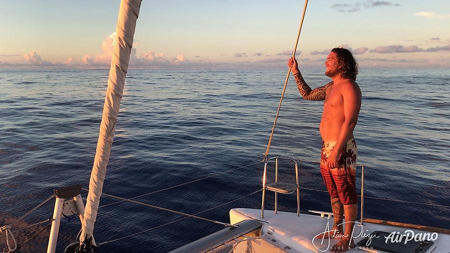
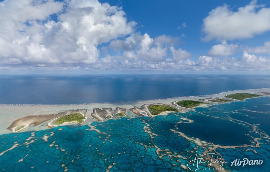
Caroline atoll was the absolute highlight and the main destination of my 2019 catamaran expedition in the Pacific Ocean.
This atoll lies around 837 km to the North of Tahiti, but it's 24 hours ahead in time. So if it is Monday on Tahiti, it is already Tuesday on Caroline — and technically, those who are on this atoll are in front of everyone else on Earth in time. This cruise had only two participants: my talented Polynesian captain, Teahui, and myself, the crazy man who in 2018 came up with the idea of contacting a Tahitian catamaran charter company, Poe Charters, to go to this remote atoll. Among the captains of this company nobody has ever been to Caroline atoll, so when this project emerged, all the captains were competing to get the job. No wonder the job was given to the best, the craziest, most daring captain. Teahui said this was a once in a lifetime opportunity for him!
© AirPano
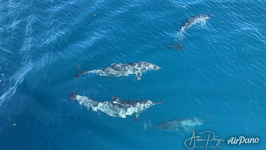
Our trip started in Tahiti. We haven't even left the outer limit of Papeete's harbour — and we already got visit from playful dolphins at the bow of the catamaran (the boat's name was Poe Reva).
© AirPano
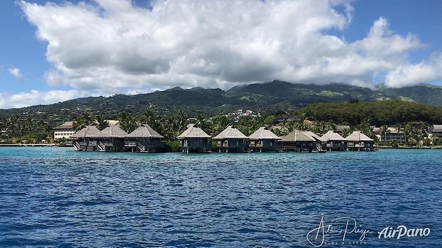
After a few hours of sailing in good wind we reached Tetiaroa, Marlon Brando's private island. You might have already seen my tour about this beautiful royal island here on AirPano. I spent a few hours flying over the lagoon of Tetiaroa, then we headed directly in the direction of Caroline atoll.
© AirPano
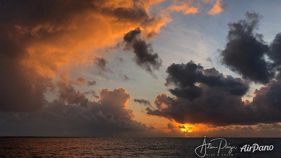
As we passed in front of the Brando resort, to the West of the island, the horizon was ablaze with orange colours of the setting sun, and the ocean was relatively calm.
© AirPano
Night came abruptly as it always does in the tropics, within minutes you are in pitch dark if there is no moon. During the night we quickly realised that the wind will not be sufficient for us to give enough force to reach Caroline atoll solely by sailing. Our speed dropped drastically. So we decided the next morning to modify the route, and we headed for Rangiroa atoll's Avatoru pass. Teahui navigated the catamaran skilfully in the crazy waters of the pass (which is subject to tremendous waves, vortexes and turbulences of water during high and low tides). In Avatoru we parked the catamaran and I went by taxi to buy up all the canisters available on the island. It was nice to see this island again, since two years before I stayed here a week. I spent more than 600 euros just on the plastic canisters for the extra fuel we needed. We replenished the tanks and the "bidons" too (as they are called in French). I made a few panoramas of Avatoru Pass, and then we continued forward to Caroline atoll.
© AirPano
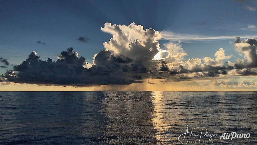
During the long crossing of the open ocean, we had to stay on guard duty during night-time — each of us did 3 hours, and then we switched. Imagine to be woken up at one o'clock in the morning, go to the decks, and check the horizon every 20 minutes for possible presence of other boats or for upcoming weather events. I also had to check the navigational parameters of the autopilot, to make sure our heading is still correct. We never encountered any other ship. Not a single one in our 18-day, 2400 km long expedition. A ghost part of the Pacific Ocean! During night, you had to be extremely vigilant on the deck: if you fall into the sea, your life is over. Teahui would never hear my screams because of the noise of the engine, and in the dark, it would be very hard to locate me among the waves. It would be game over! Therefore we had a strict rule of not drinking alcohol at all. We also had to check for weather. Rain clouds usually mean two things: either the total stopping of wind, or extreme harsh wind suddenly, so in such a case we had to lower the sails to avoid the possibility of damage.
© AirPano
One evening, at around 10, we were sitting on the top of catamaran talking, when almost in the same moment we both realised that something is fooling our senses: I have been looking at the horizon, to the East. It was a clean night, a few clouds only, the moon already well above the horizon, hovering between clouds as if framed like an old painting. Then it seemed to me that the moon — as if being a solid piece of ball — was jumping up and down, and also jittering sideways. This could not have been atmospheric shimmer, since the image of the moon was crisp, clear, its perimeter neat, razor-sharp. It moved as a whole, as one single block. Then I tried to fix with my eyes one of the close lying clouds as a reference: it was obvious to me that the moon's apparent distance to the cloud is frenetically changing. While I was thinking about this, we both asked the same question at almost the same time, after a long silence of observing the scene: What the heck is wrong with the moon??? My assumption is that this is a new type of optic illusion, generated by our brains. Since we were sitting on the top of a shaking vessel, our brain tried to stabilise the image in our heads, and this might have caused this strange phenomenon (I have only found one mention of this in the internet).
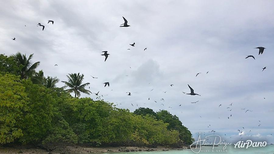
At a cruising speed of around 6 knots (roughly 12 km/h), it took us around 50 hours to arrive at Caroline atoll. How excited we were among the rolling waves when we first caught glimpse of the slim slice of land of South island! The presence of an island was already announced by the numerous seabirds who were out on their daily food hunting mission. They were very curious and already in a distance of 40 km from the atoll they approached us very closely. They were especially mesmerised by our fishing bait which was trailing 30 meters behind us in the water (we never caught any fish during our trip!).
© AirPano
The timing of our arrival was really great: it was still before noon, so we had the sun behind our back. This is crucial if you want to attempt entering the Blind Channel of Caroline atoll. It is called "blind" for a reason. It actually does not lead into the lagoon, but to a sand-shoal of South island. As no-one ever from Poe Charter came here, I did some research myself prior to the trip. I have read the book of Ron Falconer: Together alone, describing the years he spent here together with his wife and two kids. He also gave hints as to how to enter the Blind channel. I also managed to find him on facebook, so we had lots of conversation prior to the trip.
© AirPano
When we arrived at the Blind channel, our GPS showed that it lies right
in front of us, yet it was very difficult to see it with waves rolling
and breaking everywhere. We were really surprised to see how narrow it
is. Is this really the Blind channel? That's all?! The usable part was
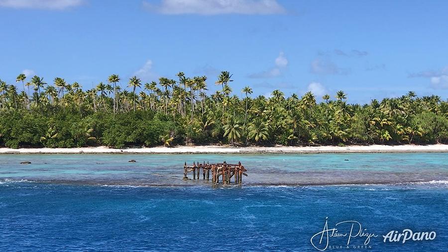
maybe 16 meters wide! The first thing you see is some shipwreck at the
entrance — this is the welcome sign of Caroline! ![]() We also knew that
this channel had some rusting iron bars protruding from under the water.
These are remains from some leftover fishing cages from around 20 years
ago.
We also knew that
this channel had some rusting iron bars protruding from under the water.
These are remains from some leftover fishing cages from around 20 years
ago.
© AirPano
I only dared to show the report about this to Teahui two days before our arrival. I told him: "I think you should read this." I was nervous to see him read it, for I knew it made him uneasy. The plan was that I stay standby with the catamaran out in the ocean while Teahui goes with the dingy (we also called it zodiac) to check the passage and see the iron bars. However, the pressure and the stress on us was such that upon arrival he just immediately went for the entry.

© AirPano
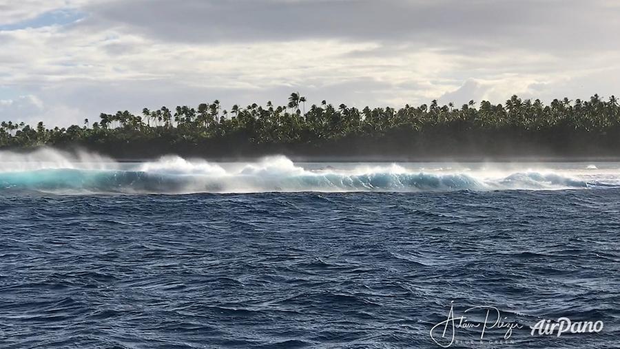
I prepared all my essential stuff ready for evacuation in case something hits the hull and we start to sink. Teahui made a fantastic entry manoeuvre. He called it a kind of suicide: no seasoned captain would ever risk getting inside with a catamaran this size. It is just too much risk! Right after reaching the gorge of the channel the catamaran had to be turned to stay clear of the coral walls of this passage. When we stopped and dropped three (!) anchors, the welcome committee has arrived. Loads of sharks! Not the very kind natured ones, since this place is so remote that even the black-tips are very aggressive, they are simply not used to see humans. When checking one of the anchors, Teahui had to kick away one grey shark with his fins. He is a native Polynesian from Tahiti, grew up with sharks and riding up to 5-meter high waves, and yet these sharks here were unsettling for him too. Better not to risk injuries so far from civilisation! Being this remote gives one a special feeling: it is amazing to see a place of great beauty largely untouched, but the further away you are from mankind, the more nervous you get. You realise even more how small we are, especially right in the middle of the vastest ocean on Earth, the Pacific! Actually, our planet should be called Water and not Earth, since more than two thirds of it are covered with water.
© AirPano
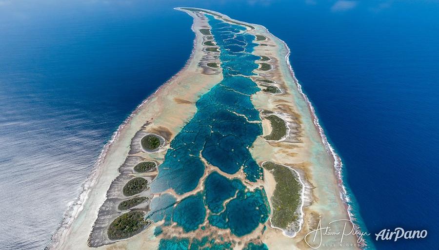
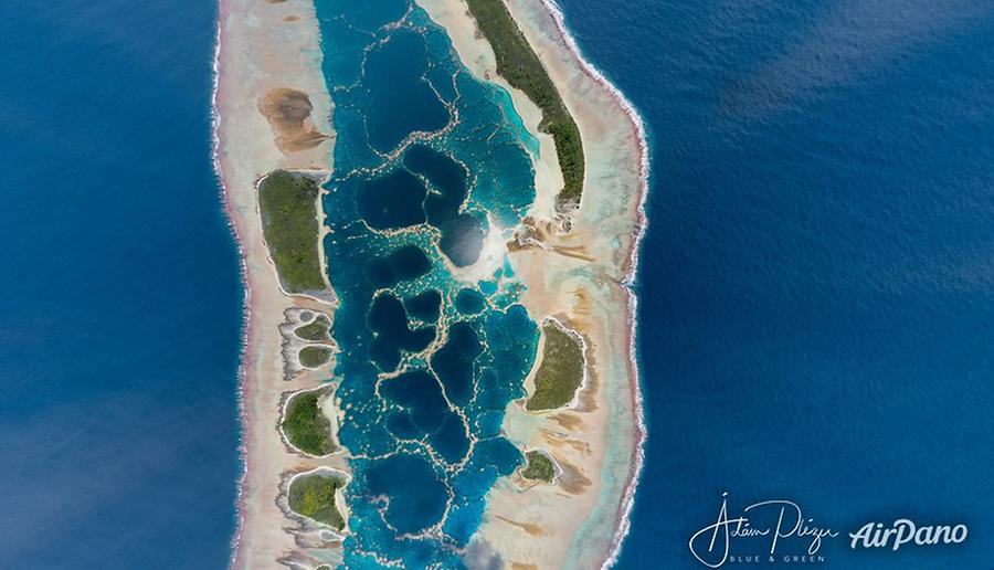
Once safely anchored (at least this was what we assumed), we had lunch, and then immediately started the aerial photography work. If you look at these panoramas you will see that the lagoon looks like a labyrinth. At some points the water is so shallow that even with our rubber dingy (which has close to zero draft in the water) it was not possible to pass. At some place we had to get out and push the boat and walk — watching out for sharks, for when you are wading in shallow water they think the splashes of your feet are made by fish in trouble, and that means lunchtime for them. Sometimes we had to jump on the boat if they came too close.
© AirPano
Normally we are not afraid of these types of sharks, I regularly swim and dive with them elsewhere in Polynesia or in West-Papua's Raja Ampat archipelago: with black-tip sharks, lemon sharks (which are quite huge), reef sharks, white tips (but of course not with the oceanic whitetip, which is one of the most aggressive shark breeds). But Caroline is a crazy, wild place regarding sharks. Your only chance of snorkelling here is by being immersed in water with full body, so the sharks can see you actually and measure your size. And then you just kick them if they get too close. In the media sharks are still demonized and people are very scared of them. For me, sharks are like dogs: most of the shark breeds pose no danger to humans, but there are a few breeds which have a natural tendency to be overly aggressive, and with those you have to be careful.
In the evening we went to Motu Ana-Ana (motu means small islet in Polynesian), I wanted to see the remnants of the small settlement that the Falconers built. I could still see the oven with the built in bottles. I wanted to make a land-based panorama there, but then I was attacked by an army of ants. So I gave up on that plan!
Back on the catamaran, I gave a call to my parents in Hungary with our onboard satellite phone, waking them at 5h30 in the morning. Later in the evening Teahui and me were discussing the next day. We would get up very early. Teahui recommended to go to the very North of the atoll first, and start panoramas there, and then gradually descend back to the South. I had a very detailed flight plan for my two drones for the 6 days we planned to stay here on Caroline. I was suggesting instead that we spend the first full day around the middle section of the atoll, since this is the most exquisite, most beautiful part of the island, and I wanted to make sure that I do the most beautiful panoramas as soon as possible. After all, you do not know what will happen, maybe bad weather or other problems. Who knows?
© AirPano
After an early rise, we had our breakfast and already at 6h20 the sun
was pounding on us with an extreme force. We clothed in full white,
long-sleeves only. We also used colourful sunblock on the cheek and
under the eyes, this product is physically covering the skin and thereby
shielding it from the burning sunshine. We started our slalom in the
lagoon, for Teahui had to learn the twists and turns and discover the
secret inner ways of this lagoon. We enjoyed very much the manoeuvres —
we burnt also a lot of fuel for it is very difficult to go around. Let
us not forget that our dingy is made of rubber, and the atoll is made of
razor sharp corals. I leave it up to you to make the connection! ![]() This
is an incredible place: though the vegetation can be rather lush, often
times it is composed of shrubs which provide little shade! So I had to
crouch like a rat under some bushes which gave not much relief from the
sun and it was very difficult to see what is going on the screen while
flying the drone. At least I
experienced how life is for birds on these motus. The atoll is home to
at least one and a half million birds. Some chicken are just waiting in
the blazing sun all day while their parents are out in the ocean
fishing. They are also very tame, you can get very close. By the end of
the day I made 36 panoramas, including those I shot the day before so I
was really satisfied. When we were heading back to the catamaran we
really hoped the catamaran would still be there and not washed out into
the open ocean.
This
is an incredible place: though the vegetation can be rather lush, often
times it is composed of shrubs which provide little shade! So I had to
crouch like a rat under some bushes which gave not much relief from the
sun and it was very difficult to see what is going on the screen while
flying the drone. At least I
experienced how life is for birds on these motus. The atoll is home to
at least one and a half million birds. Some chicken are just waiting in
the blazing sun all day while their parents are out in the ocean
fishing. They are also very tame, you can get very close. By the end of
the day I made 36 panoramas, including those I shot the day before so I
was really satisfied. When we were heading back to the catamaran we
really hoped the catamaran would still be there and not washed out into
the open ocean.
© AirPano
We were relieved to find it there neatly tucked into the Blind channel. A fish caught by Teahui from the lagoon at the Blind channel (sharks were slow and we managed to keep it for us!) was cooking in our onboard oven. We were looking forward to a delicious meal, but then we saw that the fish started to foam. Well, not a really good omen, so we decided we would not eat it. It could have had ciguatera. Ciguatera fish poisoning (CFP) is a food-borne illness caused by eating reef fish whose flesh is contaminated with certain toxins. So after all the sharks still ended up with our fish.
© AirPano
We were having a relaxed evening talk and each of us went to do some reading, before sleeping. It was pleasant to be able sleep in a more or less steady boat, since now we were quite well protected, not out in the open ocean. Well, our peace was not long lasting.
Around 2 in the night I was woken up by some terrifying noises: metal scratching on metal, scraping sounds. This sounded really-really menacing. Of course I knew immediately what it means: our anchoring was drifting, our position became unstable. The leftovers from the fishing cages, the iron bars in the water were helpful for us in the beginning, since one of the anchors got stuck in them, but after one and a half days they could not bear our weight, not even together with the other two anchors. I went up, but could not see anything, there was no moon and it was totally dark. I could not see Teahui. Later it turned out that we went up to the deck to check the situation at different times. But since in pitch dark it is impossible to do anything, we just had to wait this out. At one point I could also hear a frightening sound consistent with plastic scratching on rock — which means that our catamaran was also touching the sides of the channel, where the water is barely half a meter deep at low tide. At first light we evaluated the situation and Teahui tried to stabilise the boats anchorage. Unfortunately the currents did not allow this, and while trying, we also lost one of the anchors along with the rope. So finally we decided that instead of sinking our catamaran we would now decamp. After just 2 nights! But I was not too frustrated — I already had the most beautiful set of panoramas I ever did, and I covered the key locations of the atoll.
© AirPano
And safety lies above all! But I am not someone who easily gives up: we immediately decided that we shall return to Caroline (or Carolina as Teahui cheerfully called the island). Anyway, we need to recover the lost anchor, we know exactly where it lies, it is just at 4-5 meter depth. But for the next trip we will be three on board: there will be one more crew, so somebody will always stay on the catamaran to keep full control and supervise our floating home. If the swell won't permit an entry to the Blind Channel, the catamaran can still stay out in the ocean at standby, sailing up and down without stopping. You have to understand that it is impossible to anchor the vessel outside the atoll: the reef falls too abruptly to huge depths (during most of our odyssey the ocean's depth was 4.5 km!). If you approach the relatively shallow side of the atoll and drop the anchor, then you will be too close to the shoreline where the waves break. You do not want to lose your anchor and end up rolling and breaking on the coral reef — just as Marlon Brando did with his fisherman when he first crash-landed on his beloved Tetiaroa atoll. Our next trip will take place in April/May 2021, dates are already set, we shall visit of course Caroline, but also many other atolls in the Tuamotu archipelago!
Leaving the Blind channel was just as challenging as entering it. It was heavily turbulent, the amplitude of the waves was very high, and at the trough of one of them we almost hit one of the coral heads at the side of the channel, we were roughly 40 cm short of it. Good that we wore our brown trousers (just kidding)!

© AirPano
After Caroline we suddenly found ourselves with loads of extra time, so this permitted some spontaneous island visits. I decided that we first head to Tikehau. One of the funniest moments out on the motues was when our Zodiac was washed away by the waves and we only noticed it late, and we were left stranded on a little islet with no boat and the catamaran anchoring quite far from us inside the lagoon. That is when I saw Teahui run and swim the fastest, at olympic speeds. But we got back our boat, otherwise we would have asked a fisherman to help. After Tikehau we cruised back to Rangiroa, and we went to the Blue Lagoon where I made a quite extensive aerial and land based panorama survey of this magnificent garden of Eden. I, Adam, first of his name, absolutely approve this paradise. Inside the giant lagoon of Rangiroa (74kms long!!!) we had some massive swell (rhythmic waves), so leaving the catamaran with the Zodiac, boarding and disembarking was an extra challenge, but Teahui at least could enjoy wave surfing with our rubber Zodiac boat. So much fun it was! After Rangiora we went to Mataiva atoll. We set the engine speed such that it matched the rhythm of the swell coming from the East, so this was the best cradle-like experience we had on the catamaran. One of the best nights! Next day I had a visit of Mataviva atoll where the locals treated me with outstanding hospitality and I received a sumptuous set of necklaces made of seashells. (Mataiva impressed me so much that it will be the first stop of my expedition in 2021.)
© AirPano
By the afternoon trouble was already looming on the horizon, massive black clouds were emerging from the East. When I went back to the catamaran the swell was already 2-3 meter high. Putting the drone (and myself) back to the catamaran among the waves and in the rain was already a nice challenge. At this point we were still on the Western side of Mataiva, so relatively shielded from the Armageddon that was lurking around the corner. The swell soon became enormous, 4-5 meter waves, but with a nice wavelength, the period of the waves was quite long. We were heading to Makatea now, but the moment we left Mataiva's protecting landmass and darkness came down on us, all hell broke lose. Extremely short wave periods, 4-5 meter waves coming right from South-East, head on, 70 km/h winds, rain and darkness. It took us 9 hours to reach Makatea, but the forces to which we were exposed were astounding. According to Teahui grown-up man cry in such situations. Well at least I found out about myself that I do not, and under this stress I remained stoic and calm (I was already on land in Tahiti when the stress came out of me and I realised what we went through).
© AirPano
We were of course afraid, one has to be really stupid not to be afraid. The period of the 5 meter waves was just a few seconds. Since the catamaran was only around 12 meter long, when we reached the top of the 5 meter waves, the hull of the boat turned over the peak like a seesaw, the propellers, normally submerged in water, were out of the water and you could hear them choking. And then you sharply turn downwards and fall in a free fall and you hit with full force the trough of the waves, only to be lifted up again to the crest, and then restart the cycle. For 9 hours non-stop! We found out later that in French Polynesia all boats stayed safely sheltered in protected lagoons and basically few were out in the open ocean. Only the crazy ones. Like us. These were the very same weather conditions that on Tahiti's Teahupo generated one of the greatest swells of the last decade. But let's stop my tale of the journey right here and turn our attention back to Caroline.
After my own words I would like to introduce you Caroline atoll in a more formal manner. For this, I will cite passages from a study of Caroline atoll prepared by Angela K. Kepler and Cameron B. Kepler.
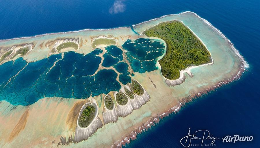
Caroline atoll, also known as Millennium Island and Beccisa Island is the south-easternmost of the Southern Line Islands, a group of 3 islands which also includes Vostok and Flint. Although archaeologically and geographically within Polynesia, Caroline is owned by the Republic of Kiribati (correct pronunciation: k?r?'bæs) formerly Gilbert islands. Caroline atoll is neither physically, geographically, nor politically associated with the Caroline islands, now part of the Federated States of Micronesia, more than 6000 km to the northwest. According to the path of the International Date Line, Caroline Island is the easternmost point of land on Earth.
© AirPano
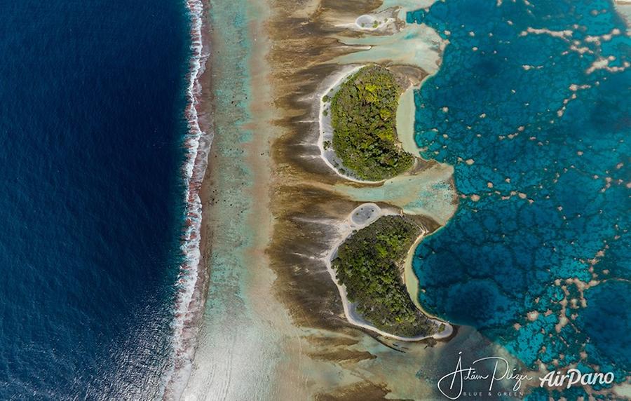
Caroline Island is believed to have originated from a volcanic hotspot which eroded and then became home to a coral reef which grew above the ocean surface.
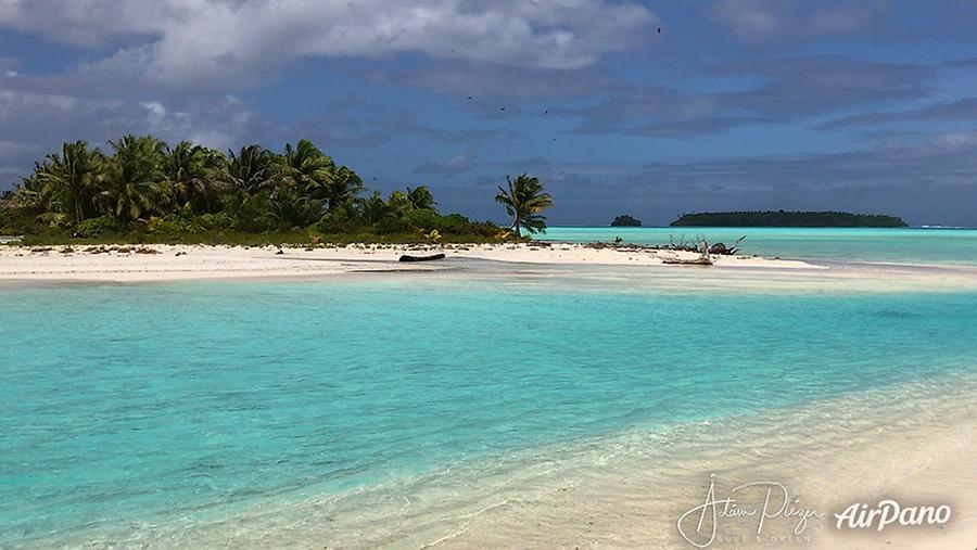
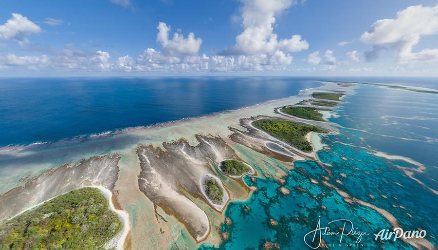
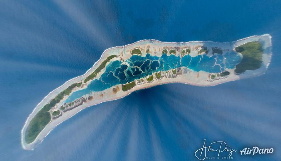
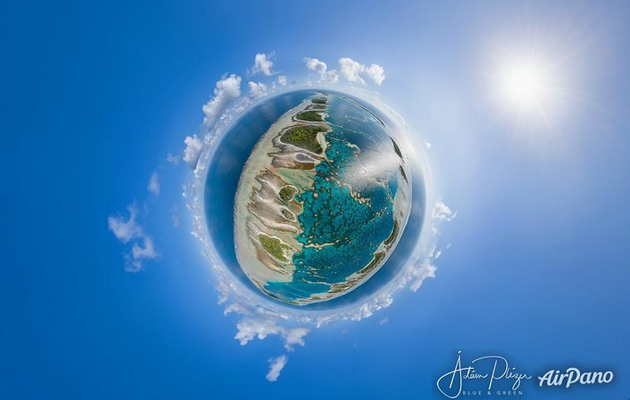
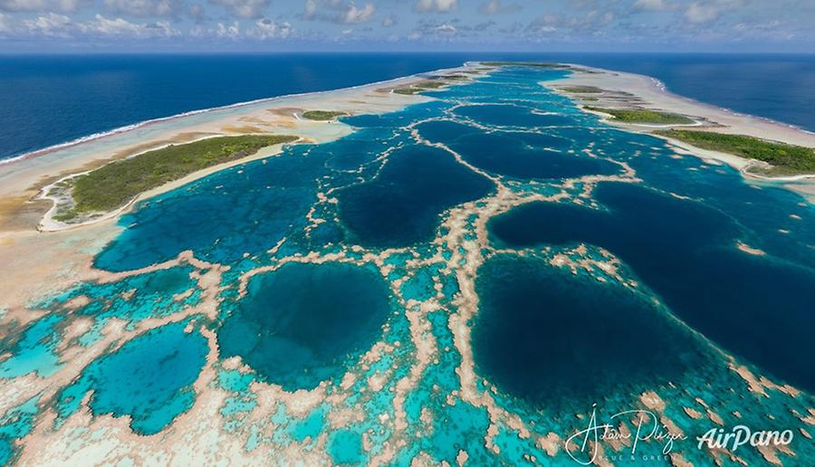
Caroline, 9.7 km long, 2.3 km wide at its widest point, is a crescentic coral ring with 39 islets (motus) centred on a continuous reef enclosing a relatively shallow lagoon. The closed lagoon, rich in marine life, contains a maze of patch reefs and impeccably clear water.
© AirPano
The atoll was "discovered" by de Quiros in 1606. It has been uninhabited since the early 1930s (a factor contributing to its relatively undisturbed ecology), except for the presence of Ron Falconer's family from 1987 to 1991. In the past decade, a lone French sailor called Lyderic set up camp on the shores of Motu Ana-Ana, but he was expelled and imprisoned by the government of Kiribati for staying there several years illegally.
Centuries before Europeans encountered Caroline, the atoll was inhabited by Polynesians. In the 1870s 50 ancient Polynesian sites were unearthed which were later identified as Tuamotuan marae (a communal sacred place). Despite its remoteness, Caroline was encountered early in Pacific history, long before Tahiti, Rarotonga and Hawaii.
As Caroline Island only extends six meters above sea level, it would be in danger if sea levels rise. The Kiribati government estimates that the island may be reclaimed by the sea as soon as 2025, and the United Nations has rated Caroline Island as among those most in danger from sea level rise.
Caroline Island is among the most remote islands on earth — 230 km from the closest land at Flint Island, 1,500 km (930 mi) from Kiritimati, 4,200 km from the Kiribati capital of Tarawa, and 5,100 km from the nearest continental land in North America.
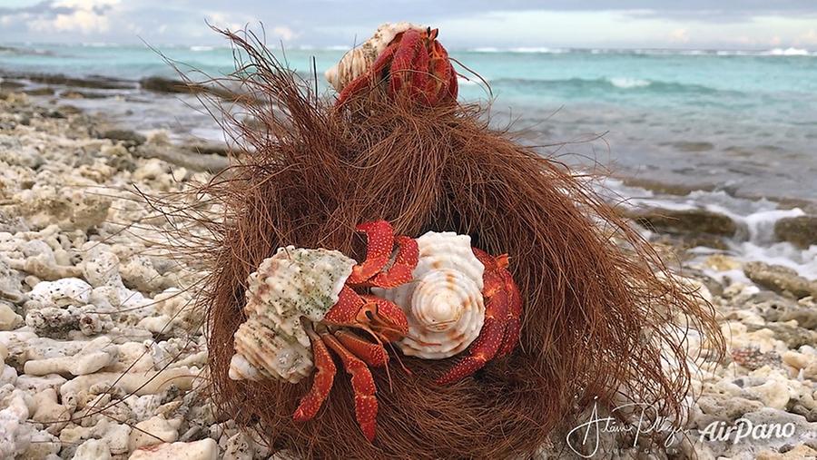
Caroline Island is an important breeding site for a number of species of seabirds, most notably the sooty tern, numbering around 500,000 — a colony of sooty terns dominates the eastern islets — and the great frigatebird, numbering over 10,000. Caroline Island and its neighbour, Flint Island, also host some of the world's largest populations of the coconut crab. Other native animals include the Tridacna clam, which is abundant in the central lagoon, hermit crabs, and multiple species of lizards.
Caroline Atoll - Ron Falconer and family#
My connection with this incredible series of Caroline photos is because Ádám Plézer the photographer, during his research and expedition preparations, discovered that our small family had settled on this remote island in the late 1980s. He needed information on the weather, the "Blind Passage" and necessary permissions required to visit the Atoll.
I admired his project and retain a strong affection for Caroline Atoll, so answered all his questions. This qualified me to be one of the first to receive these completed project photographs and the invitation to share our experiences living on the Atoll.
On opening the photographs I was amazed by the colours, texture and detail, truly impressive. This had been our island, laid out now as never before using modern drone techniques and sophisticated cameras.
© AirPano
I quickly identified the dangerous blind passage where we had risked everything to find a safe place for our sailboat "Fleur d'Ecosse" and make possible the whole venture to live on the Atoll. The tension entering the pass and the adrenaline rush were now peaceful memories, but these clear photos brought back old feelings that were so real and frightening at the time, plus the impulsive loud "yippee" we would yell once safely through the entrance and into the calm pass. This still brings a smile to my face.
In these photos the atoll looked like a piece of familiar jewellery. We had beach-combed these attractive bleached beaches looking for building materials, fished for our daily food in the turquoise lagoon waters while being super conscious of the many lurking, and often attacking, sharks. So often we had sailed our aluminium dinghy with great difficulty through what is now shown as pretty decorative patterns of live carol heads in the lagoon.
Ana-Ana, our chosen motu for it's manageable size and relative freedom from mosquitoes, now appeared alluring, peaceful and invitingly attractive. Here we had sweated clearing bushes away before building our framed sleeping hut and cookhouse, then weaving coconut leaves for covering those frames. Also a hen house for our four laying young hens and, of course, their cock.
Small rats daily raided our chopped-coconut hen food and, without permission, cheekily built their nests in our roofs. Cockroaches came by in the evenings to feast on the left overs. Beneath the attractive tree coverings we had painstakingly formed compost-filled holes and planted papayas, bananas, pumpkins, tomatoes and beans.
Tracing along these romanticized photos, I recall our productive and important fish trap, our important voyages across the lagoon to collect humus for the sustaining garden compost. Our leisurely cruises with two small children plus the dog, up the full length of the lagoon, having to constantly search for small passages through the maze of coral, while at the same time trolling a fishing line to catch a jack to be barbecued in the fire ashes for lunch. On these expeditions we brought back fishing buoys of glass, important pieces of driftwood, and occasionally a few eggs from the thousands of migrating terns.
The photos don't show the constant soaring frigates, the boobies returning with their catch from the sea, the long-tailed tropic birds, and the pure white, attentive fairy terns. Neither can you do see the hermit crabs, coconut crabs, and thankfully not the presence of hungry mosquitoes and biting ants. One positive value of a virtual world.
Settling on Caroline, for me was a progressive process: first step was leaving Scotland, sailing around the world, and discovering the Pacific Islands. As I was a bit of a wanderer, these islands suited well my personality. They were quiet, warm, with free anchoring, steady trade-winds, rich fishing, and friendly, welcoming Polynesian natives ... it all fitted. So much so that during our four years living in a small Polynesian village, on Ahe Atoll in the Tuamotu islands where our two children were born. The wanderlust had remained and I now wanted to move to an island for ourselves, a new challenge, an adventure, a next step ... I still wonder !
Caroline looked perfect, ten degrees south of the equator, more or less free from cyclones, having regular showers, and covered with coconut trees. The atoll's lease was held by an old schooner sea Captain who had regularly passaged from Tahiti to Hawaii, which passed by the island. After some persuasion he gave us permission to be Caroline's caretakers.
With our boat loaded up with stores, and towing our aluminium sailing dinghy, we set out to sail the 350 miles north to Caroline Atoll. It took a further three days circling the island before finding the right sea conditions and courage to attempt entering the risky blind passage.
What we found was a truly pristine atoll untouched by any humans for many, many years. Nature ruled here, the daily routine laid down with the interaction of the multitude of living creatures. Humbly and hesitantly we prepared to take our place in the activity of this community. We were determined to quietly integrate, and form our own private corner with a policy of minimum interference to the existing occupants, respectful of what existed and grateful to be given the opportunity to observe the daily rhythms of nature in such a pure environment.
Our own routine slowly developed, clearing our area for houses and garden, the daily fishing expedition, initially using a hand line from the dinghy, then eventually building a fish trap. Coconuts had to be collected for the hens, and to produce oil for our kitchen. Brown, mature coconut leaves had to be collected to be carefully woven into roof coverings. Three fires per day had to be lit for our cooked meals plus bread or coconut biscuits, made over the fire in a basic metal oven. Tending the garden plants and setting out new seeds.
The children amused themselves with their swing, building huts, or participating in the daily chores. They quickly learnt how to swim and use a face mask, which opening up a whole new underwater world. We went on many expeditions exploring almost all of Caroline's many motus, so clearly shown in these photographs.
All in all it was an absorbing and fulfilling experience.
After a blissful four years we became victims of a Tahiti business man: he had obtained a temporary lease and wanted to illegally kill the green turtles, exploit all the fish, coconut crabs, and everything with commercial potential on the island. Anyone watching over all his illegal enterprises was a threat, so using his connections, and blatant lies, he influenced the Kiribati Government to have us removed.
Years later, I wrote a book on our many experiences called "Together Alone", published by Random House, Australia, it is also available as an e-book, on Amazon.
24 panoramas of Caroline Atoll - Kiribati